3. Export & Share
Congratulations! You've created a beautiful custom map. Now it's time to save, export, and share your work with the world! All export options are in the main file menu:
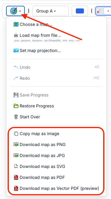
Map export options
- Open the file menu (PaintMyMap icon)
- Pick Clipboard, PNG, JPG, SVG, PDF, or Vector PDF (preview)
- Downloads start automatically (Clipboard copies instead)
Export options
PaintMyMap supports these formats:
Copy map as image
- Copies the current map to your clipboard as PNG
- Same pipeline as Download PNG: renders at ~2× the visible canvas size for crisp results
- Background is opaque and uses your current Map Background color (no transparency)
- Paste into docs, slides, or chat. If pasting isn’t supported by your app/browser, use Download PNG
PNG (Portable Network Graphics)
- Lossless raster image with crisp lines and labels
- Opaque background matching your Map Background color (set it before export)
- Same resolution as Clipboard copy (approx. 2× the visible canvas)
JPG (JPEG)
- Lossy compression (quality ~0.92); smaller files
- Thin lines/text may soften at high compression
- Opaque background using your Map Background color
SVG (Scalable Vector Graphics)
- True vector output; scales without quality loss
- Ideal for editing in Illustrator, Affinity, or Inkscape
PDF (Portable Document Format)
- Embeds a high‑resolution raster image that matches the canvas exactly
- Good for print delivery when you don’t need to edit vectors afterward
Vector PDF (preview)
- Attempts to preserve vector geometry for regions, legend, and text
- Some complex effects/patterns may be rasterized; output can vary; file size may be larger
- Use when you need an editable, press‑ready PDF; if it fails, use regular PDF
Preview mode and framing
- Use Preview to check the final map without toolbars and controls
- Exports include exactly what’s inside the map canvas: background, legend, title, shapes, and labels. UI chrome (menus/toolbars) is not exported
- Export size and aspect ratio follow the visible map area. To change the aspect ratio, resize your browser window (or split view) until the canvas looks how you want, then export
- Tip: Zoom/pan the map to re‑frame before exporting
Image quality & resolution
- PNG: Lossless; sharp labels/lines. Background is opaque. For print‑like clarity, make the map canvas larger on screen before export to approximate 300 DPI at your target size
- JPG: Lossy; smaller files, but fine details can soften. Good for quick sharing
- SVG: Vector; scales infinitely and is best for post‑editing
- PDF: High‑resolution raster embedded in a PDF; faithful to what you see on the canvas
- Vector PDF (preview): Preserves vectors where possible; some parts may rasterize
Need help?
If you run into issues with export or need advice:
- Join our community on Discord: https://discord.gg/as2tJW7GWz
- Post on Reddit: https://reddit.com/r/PaintMyMap
Troubleshooting
Common Export Issues
- Large File Sizes: Try JPG format or reduce resolution
- Quality Problems: Check preview mode and adjust settings
- Missing Elements: Ensure all elements are visible in preview
Browser Compatibility
- Best Results: Use Chrome, Firefox, or Safari
- Mobile: Export works on mobile devices
- Large Maps: May require more memory on older devices
Ready to create your first map? Start painting now.